
Tecumseh, Oklahoma Hail Report and Map: November 19, 2025
Was there hail in Tecumseh, OK on November 19, 2025? Radar estimated hail up to 0.95 inch inside the town limits of Tecumseh on November 19, 2025 (Eastern time). Radar estimates of at least 0.5 inch covered 18% of the town. Across the report area, the maximum radar estimate was 1.95 inches. The strongest part of the swath was about 6 miles southeast of Shawnee, OK. Radar detected hail aloft in this area between about 7:45 p.m. and 8:00 p.m. CT on November 19, 2025.
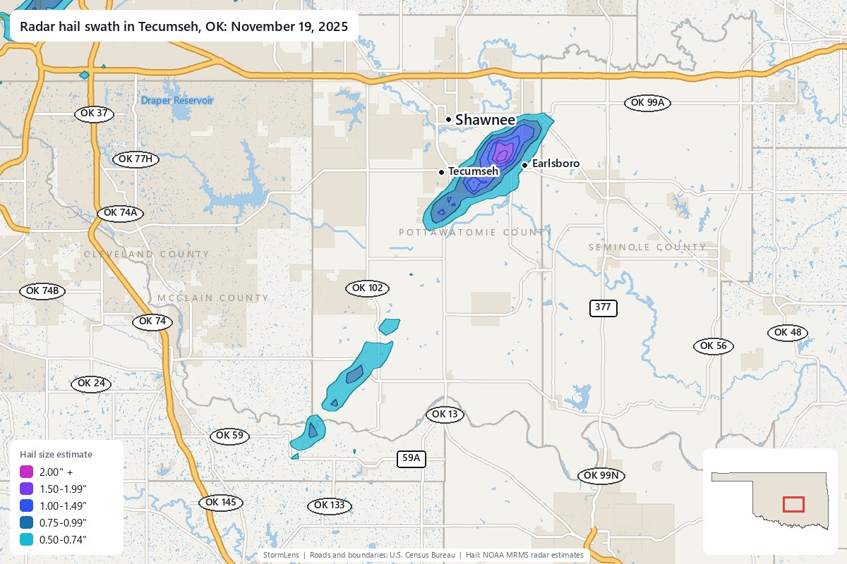
Download the free app to view this hail swath and search an address.
Hail estimates at a glance
| Storm date (Eastern time) | November 19, 2025 (Wednesday) |
|---|---|
| Maximum radar estimate across the area | 1.95 inches; strongest part of the swath about 6 miles southeast of Shawnee, OK |
| Maximum radar estimate inside Tecumseh | 0.95 inch |
| Share of Tecumseh with radar estimates of at least 0.5 inch | 18% |
| Approximate radar timing | Between about 7:45 p.m. and 8:00 p.m. CT on November 19, 2025 (Central time) |
| County coverage includes (0.5 inch or larger) | Pottawatomie County (63 sq mi), McClain County (5 sq mi) and Seminole County (2 sq mi) |
| Area with radar estimates of 0.5 inch or larger | about 69 square miles |
| Area with radar estimates of 1 inch or larger | about 15 square miles |
| Source | NOAA MRMS radar hail estimates (MESH) |
Which towns had hail on November 19, 2025?
Radar estimated hail of at least 0.5 inch inside these town limits, using U.S. Census boundaries. Each percentage is the share of town area with those estimates.
| Town | County | Maximum radar estimate inside town limits | Town area with estimates of at least 0.5 inch |
|---|---|---|---|
| Shawnee, OK | Pottawatomie County | 1.84 inches | 1% |
| Earlsboro, OK | Pottawatomie County | 1.23 inches | 55% |
| Tecumseh, OK | Pottawatomie County | 0.95 inch | 18% |
How big was the hail in Tecumseh?
Radar estimated hail up to 0.95 inch inside the town limits of Tecumseh. Among the listed towns, the highest estimate was 1.84 inches inside the limits of Shawnee. A town's maximum isn't an estimate for every home. Check the swath for estimates around an address.
What time did radar detect hail?
Radar detected hail aloft in this area between about 7:45 p.m. and 8:00 p.m. CT on November 19, 2025. We used 19 NOAA radar hail detections in this area to estimate the window. We trim outlying detection times when enough are available, then round down to five-minute marks. It doesn't give an arrival time at an address.
Data source and limits
We use NOAA's MRMS radar product MESH (Maximum Estimated Size of Hail) for hail-size estimates. Each town's figure is the maximum inside its Census town limits. The percentage is the town area with estimates of at least 0.5 inch. A town's maximum isn't an estimate for every home. Each storm date covers one calendar day in Eastern time. A late-evening storm west of the Eastern time zone can appear under two dates. Radar estimates don't confirm hail on the ground or roof damage. Hail of 0.5 to 0.75 inch can damage roofs, especially older roofs. An estimate below 1 inch doesn't rule out damage. Read how we calculate sizes and times.